

INTRODUCTION
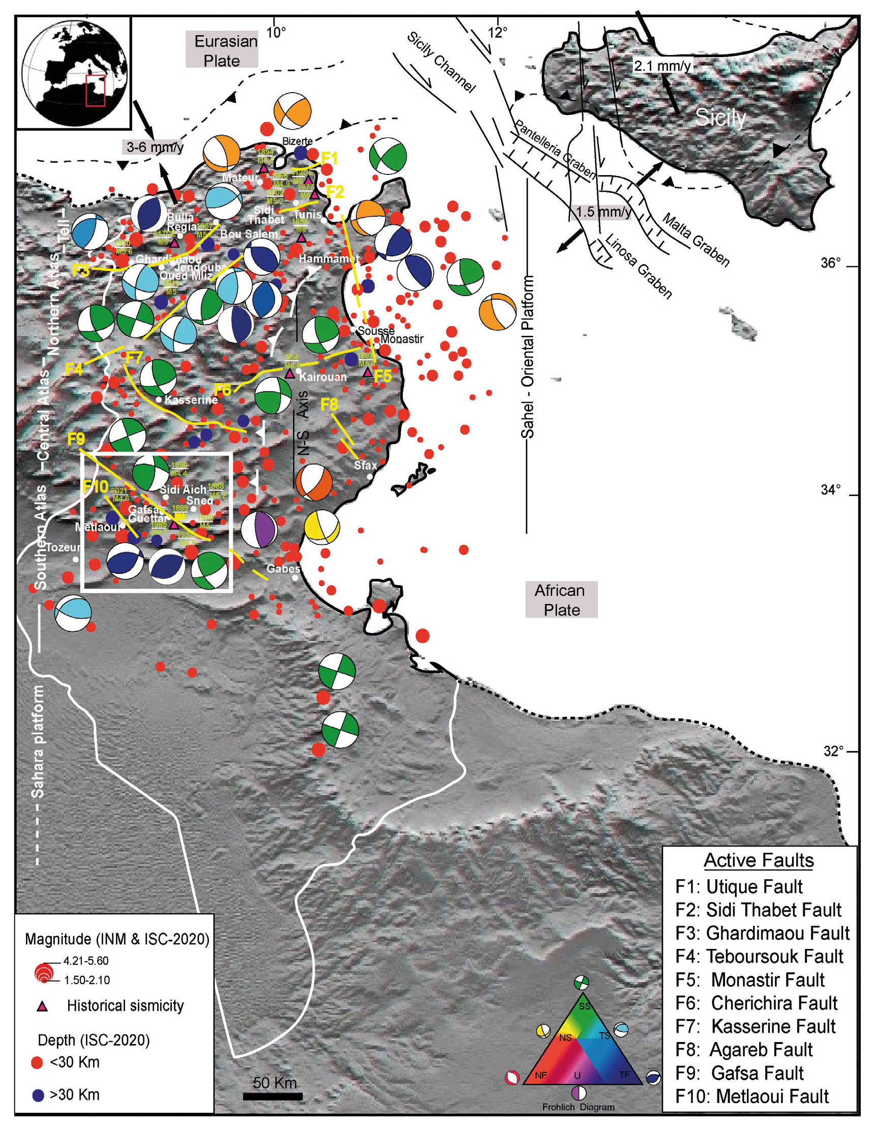
Tunisia occupies a crucial position along the diffuse convergent boundary between the African and Eurasian plates. The northward motion of the African plate, at a rate of 2-6 mm per year, drives crustal shortening and transpressional deformation (Dewey et al., 1989; Serpelloni et al., 2007; Billi et al., 2011; Nocquet, 2012; Faccenna et al., 2014; Spakman et al., 2018; Jolivet et al., 2021). This ongoing collision along the Tunisian margin is accommodated by uplift and a network of reverse and strike-slip faults within the Tell thrust belt of northern Tunisia and the adjacent Pelagian block offshore (Rabii et al., 2018; Gaidi et al., 2020; Mejri & Sayah, 2024; Mantovani et al., 2025). Several of these faults, including the Ghardimaou, Utique, and Sidi Thabet faults, have acted as seismogenic sources for significant historical earthquakes (Chihi, 1992; Soumaya et al., 2016; Kharrat et al., 2018; Gaidi et al, 2020; Mejri & Sayah, 2024). Notable events include the 412 CE Carthage-Utique earthquake (M6), the 617 CE Bulla Regia earthquake (M6), the 1677 and 1863 Tunis earthquakes (M6), the 1894 Bizerte earthquake (M5.6), the 1957 Bou Salem earthquake (M5.7), and the 1963 Mateur earthquake (M4.9, Sieberg, 1932; Mallet, 1952; Ambraseys, 1962; Rothé, 1970; Vogt, 1993). In addition to these historical events, instrumental seismicity has been recorded, including the 1970 Ghardimaou (M5.6), 2002 Sidi Thabet (M5.2), and 2013 Oued Mliz (M5) earthquakes. Beyond plate boundary deformation, several moderate-magnitude events that occurred within the central and southern Atlas belts are related to intraplate deformation. Such deformation is frequently controlled by the reactivation of deeply rooted, inherited faults. Among these, the northwest-oriented Gafsa fault stands out as the most tectonically active structure in the southern Atlas. Over the past 150 years, it has been the locus of major seismic activity, including the historical 1889 Guettar earthquake (M6; Kharrati et al., 2018) and six large-magnitude events: the 1978 Gafsa (M5), 1985 Gafsa (M4.7), 1988 Sned (M5.2), 1990 Sidi Aich (M4.4), 1992 Gafsa (M4.9), and 2021 Gafsa (M4.6) earthquakes. It is worth noting that intraplate seismicity in Tunisia is characterised by shallow hypocentres, with focal mechanisms revealing a combination of reverse and strike-slip faulting (Fig. 1). These events reflect the reactivation of inherited Mesozoic rifted margins under Neogene-Quaternary compression (Zouari et al., 1990; Dlala et al., 1994; Frizon de Lamotte et al., 2009; Gharbi et al., 2014; Soumaya et al., 2020).
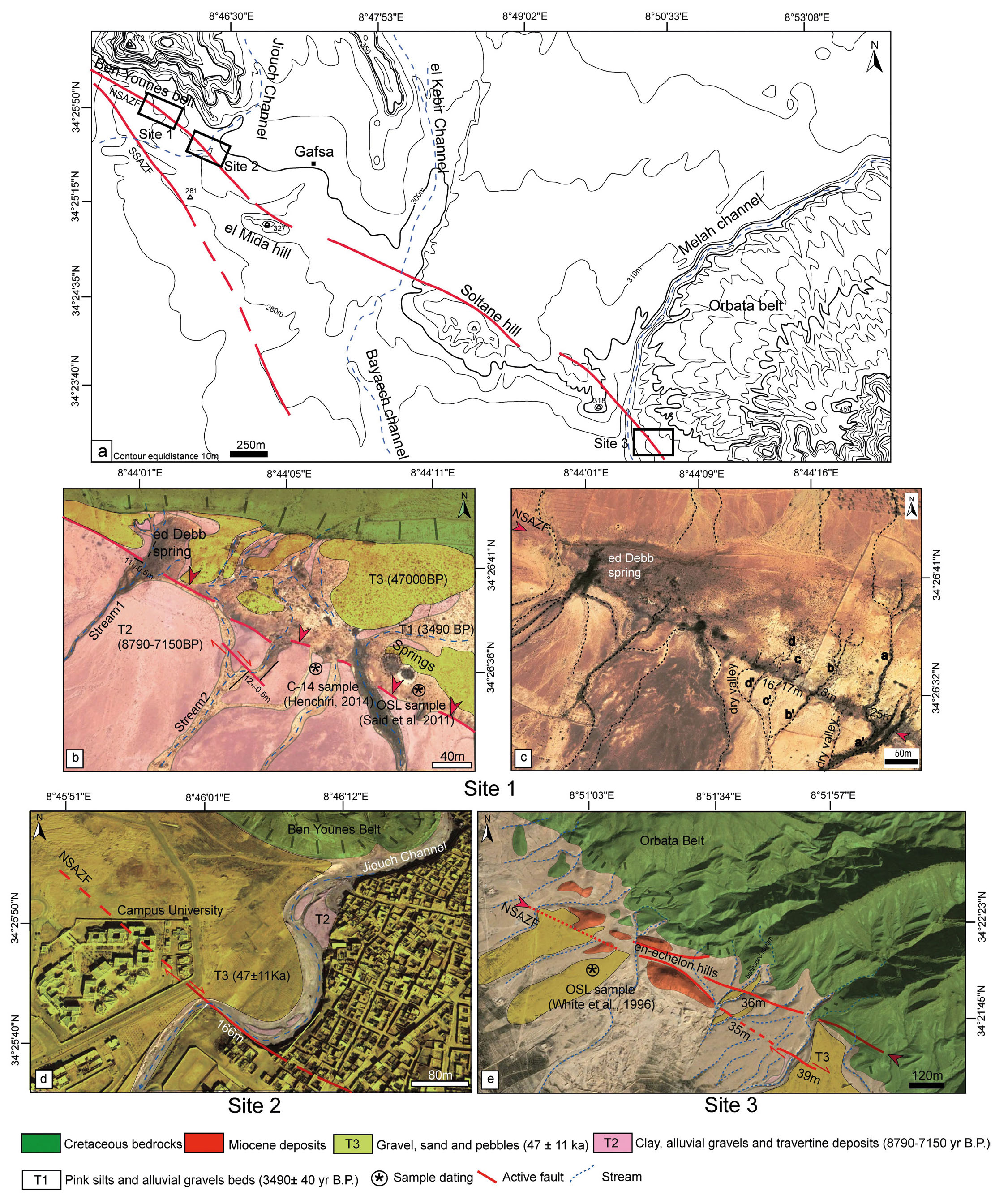
- Simplified tectonic map of Tunisia. Active faults are mapped from Tunisian geological maps (modified after Dlala & Hfaiedh, 1993; Boutib & Zargouni, 1998; Bouaziz et al., 2002; Soumaya et al., 2016). Dots indicate instrumental seismicity data compiled from the Institut National de la Météorologie-Tunisia (INM) catalogue and the International Seismological Centre (ISC) bulletin, colour-coded with according to epicentre depths. Historical earthquakes with estimated magnitudes, shown as coloured triangle, are reported from Kharrati et al. (2018). Focal mechanisms are sourced from INM, RCMT, and ETHZ. The Frohlich diagram categorizes fault types as follows: NF (Normal Fault), NS (Normal-Sinistral), TF (Thrust Fault), SS (Strike-Slip Fault), TS (Thrust-Strike), and U (Undefined). The white box highlights the study area shown in Figure 2. The base map is a shaded DEM map (SRTM) with a 30m grid-size.
The strain partitioning and intraplate deformation in continental collision zones, such as the southern Atlas, underscore the importance of accurate geological and seismotectonic studies for such regions located hundreds of kilometers away from the active African-Eurasian plate boundary. These studies are crucial for evaluating Quaternary slip rates and seismic recurrence in the far-field deformation region of Gafsa. Geomorphic analyses can help bridge the gap between short-term geodetic data and long-term tectonic models, providing robust constraints on fault behavior, earthquake recurrence intervals, and regional strain accommodation (Van der Woerd et al., 1998; Roberts & Michetti, 2004; Zielke et al., 2012; D’Amato et al., 2016; Stewart et al., 2018). By integrating geomorphic mapping, precise field measurements, and robust dating techniques, geomorphic markers such as deflected channels and displaced terraces serve as reliable archives of cumulative fault displacement. These markers offer valuable insights into both strike-slip and dip-slip motions over millennial timescales (Wallace, 1987; McGill & Sieh, 1991; Avouac & Peltzer, 1993; Gawthorpe & Leeder, 2000; Cunningham & Mann, 2007; Zhang et al., 2017; Liu et al., 2022). Furthermore, the estimation of fault slip rate is an important parameter for understanding the seismotectonic characteristics of tectonically active regions. Quantifying fault movements over time provides valuable data for more comprehensive earthquake probability models (Han & Mao, 1993; Pace et al., 2006; Chartier et al., 2017; Ghribi et al., 2018; Bai et al., 2021).
Recent studies have primarily focused on the interaction between Quaternary travertine formation, driven by hot spring activity, and the dip-slip movement along the Gafsa Fault. Vertical to near-vertical resistivity gradients have been associated with NW-trending normal faults (Ben Ahmed et al., 2023; Mahmoudi et al., 2024). Paleoseismic trenching has provided vertical slip rate estimates ranging from 0.21 to 0.34 mm/yr (Said et al., 2011). The presence of well-preserved fault scarps offers a valuable opportunity for us to further investigate the vertical slip rates of different Gafsa Fault Strands. However, a comprehensive and systematic analysis of stream channel offsets along its strike-slip component remains lacking.
This paper is structured as follows: we first present the regional geological and tectonic setting of the Southern Tunisian Atlas, followed by the methods used to map and analyze fault-related landforms. We then describe field observations and offset measurements at selected sites, which form the basis for our slip rate estimations. Finally, we discuss the implications of these findings for fault segmentation, earthquake recurrence, and regional seismic hazard. The study focuses on the Gafsa intraplate fault, the most seismically active structure in the Southern Atlas (Boukadi, 1994; Chekhma et al., 1997; Ahmadi et al., 2013; Ben Hassen et al., 2014; Athmouni et al., 2022; Mahmoudi et al., 2024), to investigate the relationship between strike-slip faulting and the cumulative displacement of drainage systems. Our objective is to quantify the recent kinematics and seismic potential of the Gafsa Fault System through detailed geomorphic measurements, field investigations, and existing chronological data. To better understand fault behavior, we analyze deflected stream channels, alluvial terraces, and fault scarps along key segments of the fault. These analyses are essential for reconstructing the slip history and improving seismic hazard assessments, particularly in the densely populated Gafsa region.
GEOLOGICAL SETTING
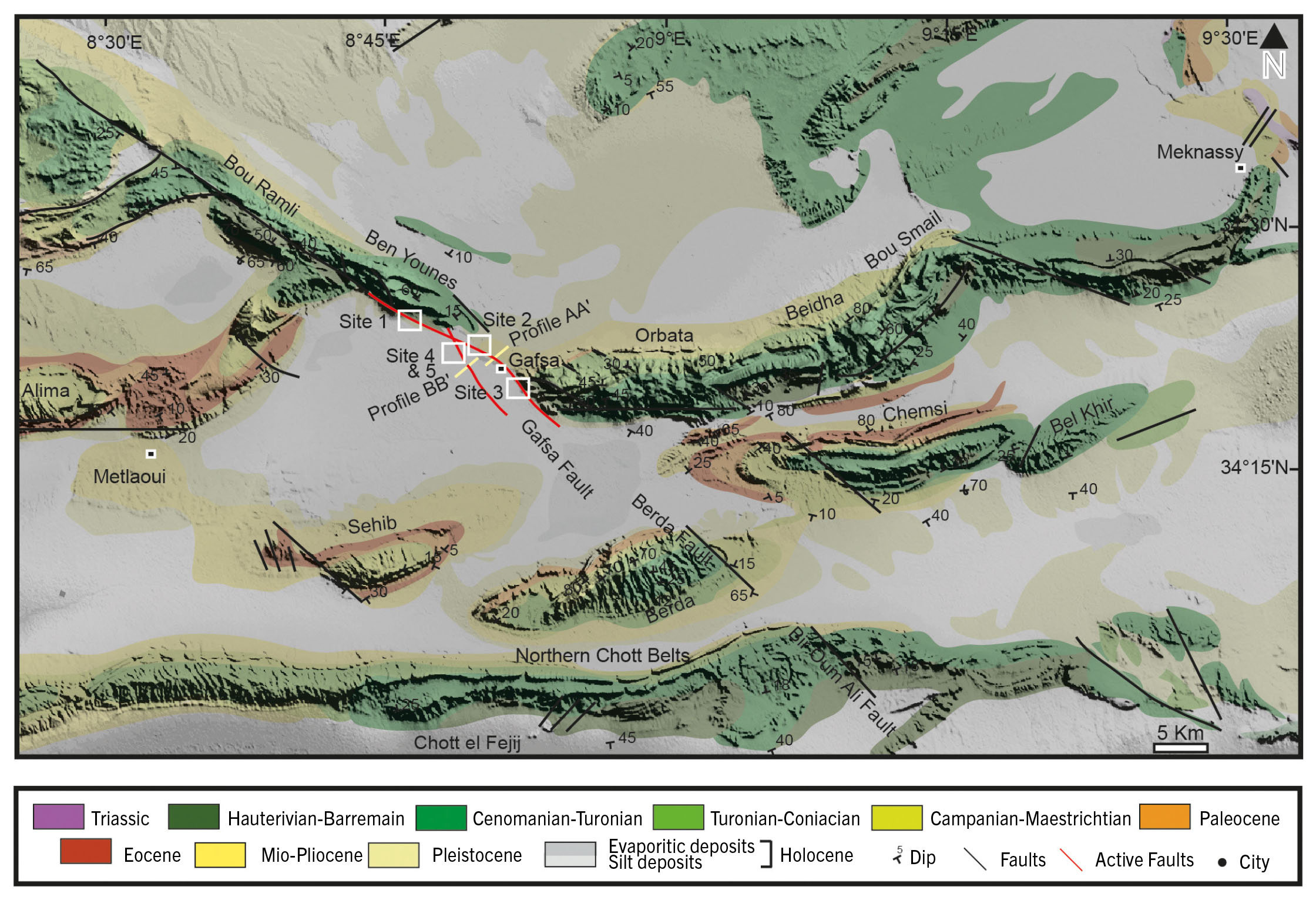
The studied landscape is characterised by three main fold-thrust mountain ranges with an overall E-W strike, which include: (1) the 120 km-long northern Chott belts, which form a transition between the Atlas fold and the northern edge of the Sahara platform; (2) an isolated, elongated belt comprising Sehib (558 m), Berda (794 m), Chemsi (789 m), and Bel Khir (587 m), trending E-W to N60°E; and (3) the northern part of the Southern Atlas of Tunisia, represented by the Alima and es Stah belts, which are perpendicular to the NW-striking Bou Ramli (1156 m) and Ben Younes (901 m) mountains. To the east, the Orbata and Beidha belts curve towards a NE-SW direction near the city of Meknassy (Fig. 2).
- Geological map of the Southern Atlas (adapted from the 1:500,000 scale geological map of Tunisia (Geological Survey of Tunisia, 1985; Slimane et al., 1991; Ben Youssef, 1999; Gallala et al., 2009). The background features a 90m DEM from ALOS World 3D (Takaku et al., 2014). Red lines are the active Gafsa Fault system. Black circles represent towns. White boxes outline the investigated sites. Traces of the profiles AA’ and BB’ given in Fig. 7 are indicated.
Geodynamic context of the Southern Atlas
The Southern Atlas underscores a polyphased tectonic history that began with the N-S extensional periods of Triassic, Jurassic and Early Cretaceous (Ben Ayed, 1980; Zargouni, 1985; Burollet, 1991). They associated with the NW-SE to E-W opening of the Tethys during the dislocation of Pangea (Dercourt et al., 1986). During this period, the Gafsa Fault zone operated like a dip-slip fault system where strong differences in subsidence rates between hanging wall and footwall are evident (Boukadi, 1994; Zouaghi et al., 2011). This zone was later tectonically inverted after the Late Cretaceous to Eocene times where the Gafsa Fault displays thrusting and over-thrusting deformation activities (Ahmadi et al., 2013). It is a consequence of large-scale continental collision at African-Eurasian plate boundary related to the Tethys closure. Some authors argued the development of the Gafsa belts to salt tectonics (Hlaiem, 1999; Amamria et al., 2014). During the Miocene, a NW-trending compressive deformation propagated through a much large areas of the western part of the Mediterranean domain covering the Tell belt to the south and reaches the Southern Atlas (Leprêtre et al., 2018). Such deformation is frequently controlled by the reactivation of deeply rooted, inherited faults (Gharbi et al., 2014; el Amari et al., 2016; Masrouhi et al., 2019; Bahrouni et al., 2020). Coeval strike-slip and thrust tectonics characterised the inverted Gafsa Tertiary basin where they document palaeohighs and depocentres interpreted as echelon folds (Chihi, 1992; Chekhma et al., 1997). These pre-existing structures can be reactivated by far-field stresses, particularly during major N160 trending σ1 of the Quaternary tectonic event. During this time, the Gafsa Fault exhibits right-lateral slip since the Pleistocene (Bouaziz et al., 2002; Dhahri & Boukadi, 2010).
Regional geology
The exposed strata along the Gafsa Fault comprise both Lower and Upper Cretaceous rocks, primarily made up of dolomitic limestone and clay (Fig. 2). The Lower Cretaceous sequence, several hundred meters thick, reflects a transition from fluvial and deltaic to marine depositional environments. The Hauterivian, Barremian, and Aptian deposits show significant thickness variations, attributed to synsedimentary tectonic activity. From the Cenomanian to Campanian, the sequence becomes more dolomitic, indicating a predominantly marine setting. This interval includes Turonian, Coniacian, and Santonian deposits, mainly composed of marls, limestone, and evaporites, and is associated with lagoonal environments (Abdallah et al., 2000; Salmouna et al., 2014). In the Gafsa Basin, the upper Paleocene to lower Eocene interval is characterised by evaporite deposits, phosphatic limestone and clay, and fossiliferous limestone. It is related to circalittoral to marginal littoral palaeoenvironments (El Ayachi et al., 2016; Messadi et al., 2020). Neogene deposits in the region consist of sandstone facies interbedded with pebble conglomerates (Fig. 3). These sequences, which include stream-flood, sheetflood, and debris flow deposits, are deposited in relatively flat terrain between southern Atlas belts. At El Mida Hill, uplifted alluvial deposits contain pebble-culture artifacts that are attributed to the Late Paleolithic period (35,000 to 10,000 BP) by Collignon (1887), Vaufrey (1932) and Denizot (1935). They are overlain by Late Pleistocene to Holocene travertines and tufas. The carbonate precipitates exhibit diverse field textures, including residual buttes (mounds), stromatolitic laminations, plant molds and imprints, and tubular conduits. According to Henchiri et al. (2014), these features are likely of Late Pleistocene to Holocene age. Their formation is linked to carbonate-rich water upwelling along segments of the Gafsa Fault (Ben Ahmed et al., 2023).
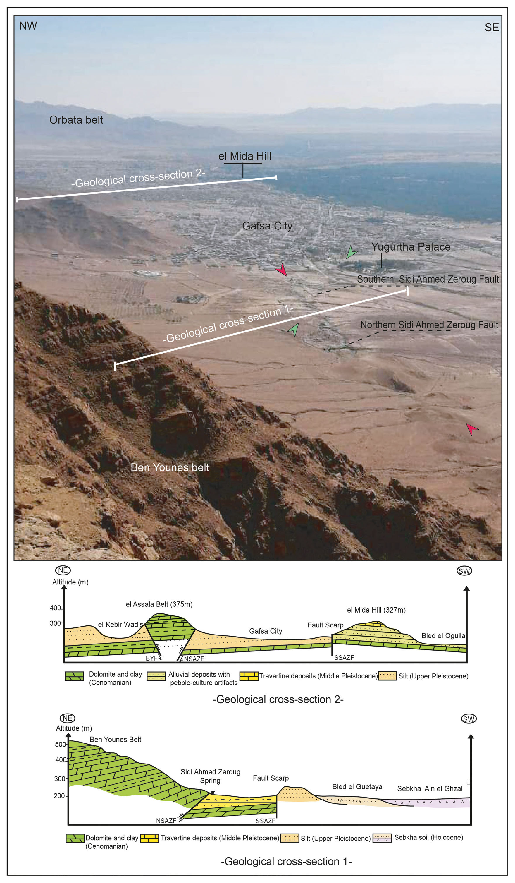
- Geological cross-sections through the Gafsa Faulted Zone, illustrating the structural configuration and segmentation of the North and South Sidi Ahmed Zeroug Faults (NSAZF and SSAZF).
METHODS AND DATA PROCESSING
Identification of fault traces
The slip distribution of the Gafsa Fault system cannot be assessed using LIDAR and UAV images due to the proximity to El Ksar Airport, which restricts UAV takeoff. Therefore, the line shape of the Gafsa Fault system was mapped through landform investigation of satellite imagery, 1:100,000-scale topographic maps and analysis of digital elevation models (DEMs) derived from Sentinel imagery and Shuttle Radar Topography Mission (SRTM) data. Field investigations at observation sites in the studied area are crucial for constraining the quantitative kinematic deformation. These investigations involved measuring both the horizontal and vertical components of offset in Quaternary features. Identifying fault traces from the images based on offset landforms is challenging, as they are often obscured by dense vegetation in Gafsa town. Furthermore, significant urbanisation in the nearby Gafsa city has drastically altered the Gafsa Fault traces, with many fault scarps and displaced landforms being destroyed. The best sites for investigating the fault stretch were selected for geomorphic studies to better understand the recurrence behavior and displacement accumulation within the southern Tunisian Atlas. These sites are characterised by (1) well-preserved slip zones surrounding the fault, evident in the surface topography, and (2) the cumulative slip amount during successive earthquakes, which was determined from clusters of offsets with varying mean offset values using the “back-slipping” method (Manighetti et al., 2007; Zielke et al., 2015, 2018).
Segmentation of the Gafsa fault system
The trace of the Gafsa fault is easily identifiable on satellite images and through field observations. It has been segmented into three sections from north to south based on fault trace geometry. The northern strand, approximately 20 km long, is the Ben Younes- Bou Ramli Fault (YRF), which represents a continuation of the N130°E-striking Souk Ahras Fault in the Algerian Atlas belts. To the southwest, the N120°E-striking Gafsa shear zone forms a straight line clearly visible on satellite images and exhibits a wine-glass shape at its eastern tip. Here, the southern strand, approximately 25 km long, crosses the Gafsa foreland basin and splits into two fault segments of varying lengths, depending on gaps in the fault trace and orientation. The northern strand, called the Northern Sidi Ahmed Zeroug Fault (NSAZF), coincides with the central segment of the Gafsa Fault, while the southern segment is represented by the Southern Sidi Ahmed Zeroug Fault (SSAZF). At the southwestern tip, Miocene continental deposits are tectonically in contact with Cretaceous rocks. It is worth noting that at coordinates 34°26’29.62’’N and 8°44’21.33’’E, the strike of the southern strand shifts to N140°E before extending further east into the Berda-Fejij Fault system. This strand is characterised by a N140°E-striking morphology of ridged Quaternary terrains, ranging from 280 to 380 m in height, in the Gafsa city area. The Gafsa Fault system cuts through the Sidi Ahmed Zeroug Hill (284 m), El Mida-Signal Hill (380 m), and Ragoubet el Helou-Soltane (370 m; Fig. 3).
Measurement of offset-landforms
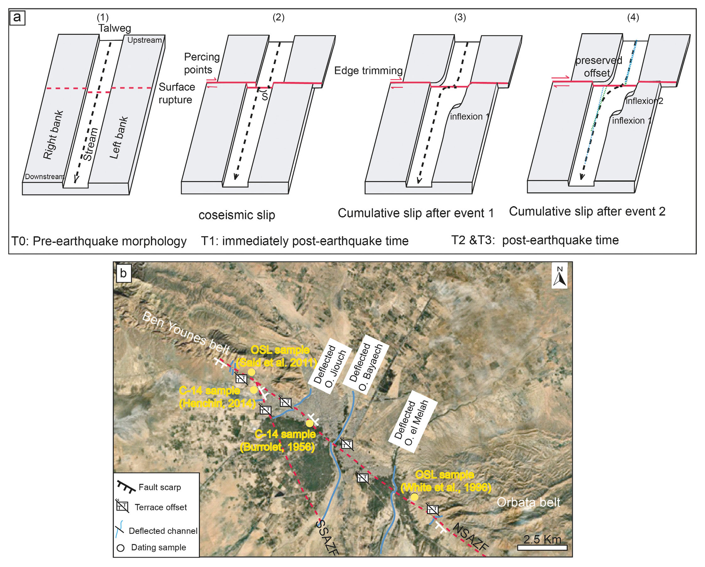
Alternating episodes of aggradation and degradation have occurred repeatedly during the late Quaternary and Holocene, contributing to the development of a dense alluvial network and the formation of various geomorphic features (e.g., terrace risers, ridges, alluvial fans, etc.). These offset landforms are valuable tools for inferring both lateral and vertical displacement along active strike-slip faults. These displacements are attributed to multiple events and individual palaeoearthquakes. The uncertainty in offset determination mainly arises from the shape and sinuosity of geomorphic markers, the fault’s location, and the geometry of the intersection between the geomorphic marker and the fault traces. The apparent lateral offsets of rivers, for example, may have been influenced by the presence of bedrock. Consequently, channel deflections and fault-parallel channels formed around these obstacles. Reconstructing the pre-earthquake morphology of stream channels displaced by individual segments along the active strike-slip fault was essential for assessing vertical displacement, which was estimated using topographic profiles extracted across the well-preserved fault scarps (Fig. 4a).
- (a) Schematic representation of channel geometry showing lateral displacement (modified from Guo et al., 2021). (1) The channel riser sections on both banks, along with the linearity of the stream, provide the best basis for estimating lateral displacements. (2) Coseismic deformation occurs along a right-lateral strike-slip fault (red lines). The amount of slip (S) is estimated using piercing point method. (3) Post-earthquake morphology is influenced by ongoing sedimentation and erosion processes. Note that displacement measurements on the left bank may be underestimated due to erosion at the offset corner. The eroded material contributes to the formation of an inset terrace. Therefore, it is more reliable to measure displacement using the riser on the right bank. (4) Inflexions observed on the left bank result from cumulative offsets across multiple seismic events. The most recent event corresponds to the inflexion near the fault. (b) Map showing the location of displaced geormorphic markers and dated terraces relative to the Gafsa fault strands.
RESULTS
The Gafsa Fault system exhibits both right-lateral strike-slip and dip-slip activity. A total of 32 local, preserved Quaternary features, serving as geomorphic strain markers, were identified with varying right-lateral offsets. Additionally, 5 vertical offsets were measured along the NSAZF and SSAZF strands (Fig. 4b). We selected three sites, located to the south and north of the Bayaech channel stream, where the northern segment of the Sidi Ahmed Zeroug Fault (NSAZF) is well recognised, in order to reconstruct its fault slip rate using satellite imagery (Fig. 5a). The faulted landforms along the SSAZF trace are well preserved, offering favorable conditions for studying the fault’s surface slip characteristics. However, determining the slip is not possible in some areas due to the geographical environment of the studied fault branch, where terrace risers are obscured by dense vegetation around several springs and by urbanised areas. To the south, at the intersection with the Bou Ramli-Ben Younes Fault, the deflected streams are diffuse and indistinguishable for displacement estimation, as they have been artificially smoothed. These streams were not considered when estimating fault displacement.
- (a) Elevation contour lines illustrating the background topography, simplified from 1:100,000 topographic maps of the Gafsa region. Red lines represent the northern and southern splay faults associated with the Sidi Ahmed Zeroug Fault system (NSAZF and SSAZF). The boxes highlight selected sites used for offset measurements. (b) An offset of 11-12 meters is observed on a fluvial terrace displaced by the North Sidi Ahmed Zeroug Fault (NSAZF). Arrows indicate the location of the fault trace. (c) Offset drainage channels, labeled a through d, are aligned along the NSAZF. (d) Satellite imagery taken prior to highway construction shows right-lateral offsets of the southward-flowing Jiouch Wadis. (e) Offset measurements of drainage channels at the El Soltane site. The studied fault creates a topographic step separating the Orbata foothills from the alluvial plain, which is incised by deflected streams. These streams exhibit consistent lateral displacement values of approximately 35 ± 4 meters.
Lateral offset drainage pattern measurements
Northern Fault strand (Northern Sidi Ahmed Zeroug Fault- NSAZF)
South of the Bayaech channel, extending to the northwestern edge of the Ben Younes Belt and reaching Gafsa town, the NSAZF exhibits a well-defined trace that distinctly separates the Ben Younes Belt from the Sidi Ahmed Zeroug Basin. This fault dissects several streams that flow southward along the gentle slopes of Ben Younes, where well-developed alluvial fans and fluvial terraces are present. Each terrace is characterised by distinct sedimentary facies and topographical features. Moving away from the Ben Younes Belt and toward the south, we identified three primary terrace levels: Terrace 3 (T3), the oldest terrace, is composed of gravel, sand, and pebbles, with an OSL age of 47 ± 11 ka (White et al., 1996); Terrace 2 (T2) is characterised by clays and alluvial gravels, capped by travertine deposits dated to 8,790 ± 50 and 7,150 ± 70 BP (Henchiri, 2014); Terrace 1 (T1), the youngest terrace, consisting of pink silts and green clays, capped by a calcrete layer, dated to 3,490 ± 40 BP (Said et al., 2011).
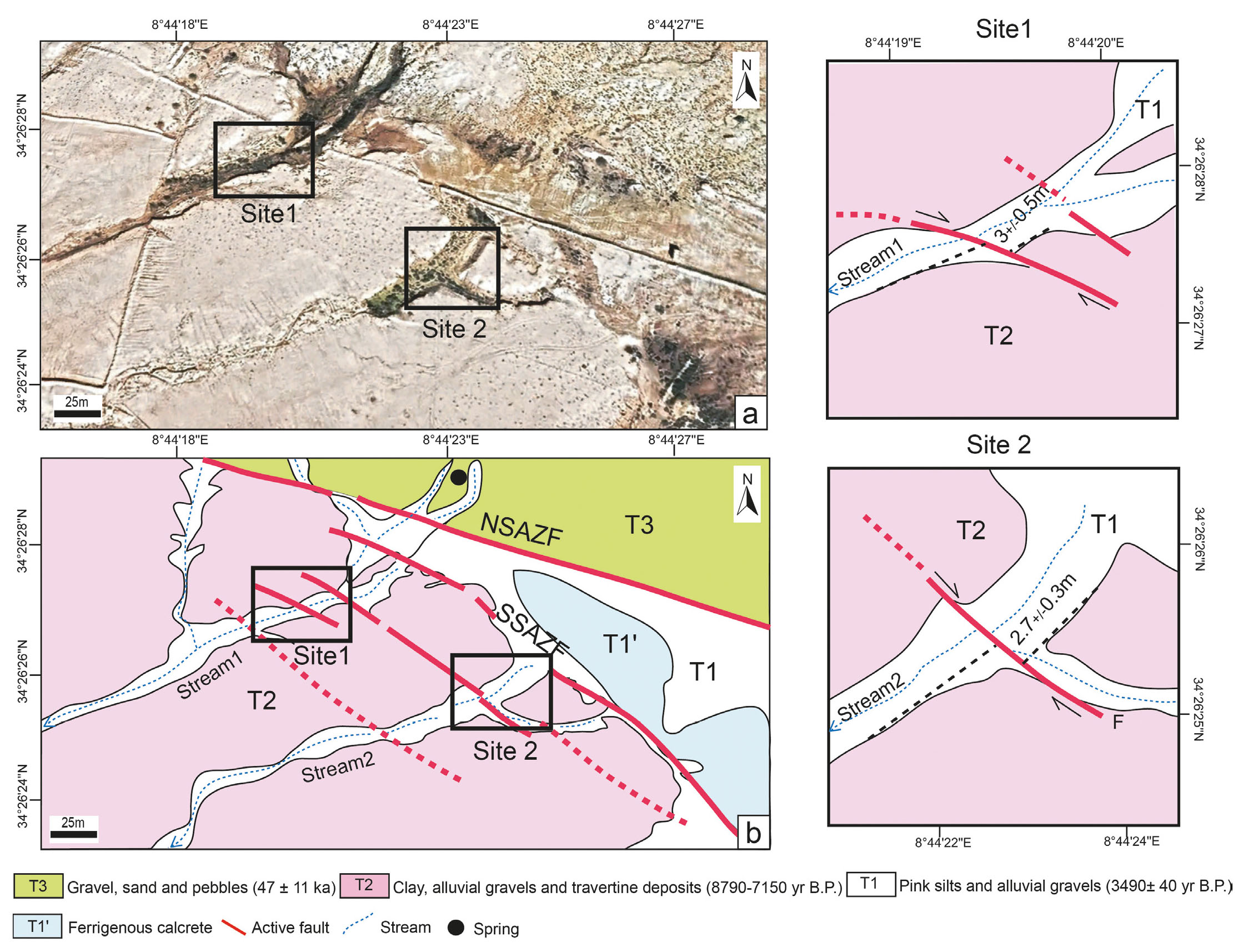
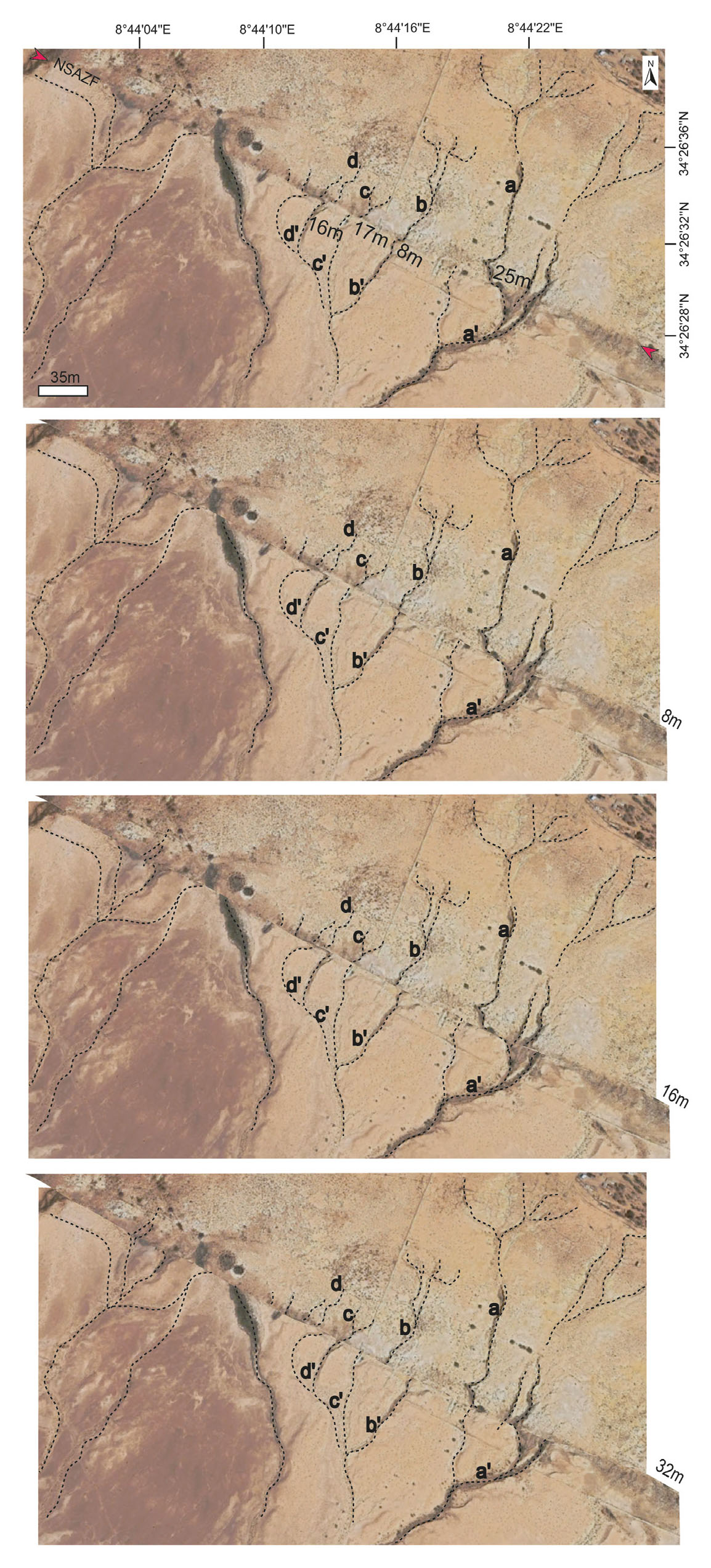
Field investigations, supported by satellite imagery, reveal that the T2/T1 riser on the western bank of the southward-flowing Ain Debb wadis has been right-laterally displaced by the NW-striking NSAZF. Additionally, a spring emerges from the fault at the T1 terrace. The right-lateral displacement at this site is estimated at 11-12 ± 0.5 meters (Fig. 5b). Furthermore, at least three deflected streams and fault-parallel channels serve as key indicators of lateral offsets. These features were mapped in high-resolution satellite imagery and validated through field observations using differential GPS measurements. The offset values were determined by projecting displaced geomorphic features back to their presumed original positions across the fault, following the piercing method. A preliminary analysis shows that these features appear to align with outlets on the opposite side of the Northern Sidi Ahmed Zeroug Fault and identifies three primary offsets: 8 meters, 17 meters, and 24 meters. The smallest offset (8 meters) may represent the coseismic displacement from the most recent seismic event along the NSAZF segment. Larger offsets of 17 meters, 24 meters, and 32 meters represent cumulative displacements, approximately two, three, and four times the magnitude of the most recent event (Fig. 5c).
The second site represents the most distinct geomorphic expression of tectonically offset channels along the Northern Sidi Ahmed Zeroug Fault. It is located near the university campus and east of the Tozeur-Gafsa highway. At this site, the T3 terrace has developed on the western bank of the southward-flowing Jiouch channel, approximately 15 meters above the stream. It is primarily composed of well-sorted and rounded coarse fluvial sands. A geomorphologic study conducted by White et al. (1996) proposed an OSL age of 47 ± 11 ka B.P. for the T3 terrace. The terrace riser of T3 on T2 in the western bank of the Jiouch wadis has been right-laterally offset by 166 meters (Fig. 5d).
The third site is located 13 kilometers north of the first site, along the slopes of the Orbata Mountains. Here, the imprint of the NSAZF trace becomes increasingly pronounced in the landscape, where it splays into several secondary, oblique-trending dextral faults. These faults form well-expressed en-echelon hills of Miocene age. The site is situated between latitudes 34°22’35’’N and 34°21’43’’N and longitudes 8°50’42’’E and 8°52’13’’E. The mountain slopes in this area are densely vegetated, particularly around the southward-flowing Melah channel, where the Soltane spring emerges from the fault. The topography is dominated by the NW-oriented Ragoubet el Helou-Soltane hill, which rises to 370 meters. By integrating high-resolution topographic data interpretation with field investigations, the left bank of the Melah stream shows a dextral offset of 38 meters, which we interpret as the cumulative effect of repeated fault slip (Fig. 5e). However, significant uncertainties exist regarding the right bank of the Melah stream, where the riser has been artificially modified. At the Orbata site, located 3 kilometers from the Melah stream along the Orbata Mountain slopes, multiple serially spaced and incised streams orthogonally cross the NSAZF. These streams have been right-laterally offset by 35 ± 4 meters. Similar to site one, the larger offsets here are classified as cumulative effects of repeated slip along the Gafsa Fault.
Southern Fault Strand (Southern Sidi Ahmed Zeroug Fault- SSAZF)
The study site is located near Hotel Yugurtha Palace, approximately 2 kilometers northwest of Gafsa town. The southern strand of the fault is oriented at N140°E, differing from the northern segment of the Gafsa Fault. The angle between these two branch faults is approximately 10-20°. The right-lateral strike-slip system appears to extend further south of Gafsa town. In this faulted area, streams are generally longer and steeper on the upstream block, with greater valley incision. At least three springs have been identified, contributing to the development of a swampland landscape and a fault trough. In this section of the SSAZF, as shown in Figure 6a, we estimated the strike-slip rate across the fault zone. Along its weathered trace, terrace risers serve as geomorphic markers, though their imprints in the topography are subtle, making offset measurements challenging. Based on field investigations, the upstream and downstream segments of the streams run perpendicular and slightly oblique to the fault trend. The T2/T1 riser on the left banks of streams 1 and 2, located near the fault, is well preserved and records a Holocene lateral offset of 2.7-3 meters (Fig. 6b).
- Faulted fluvial terraces along SSAZF. (a) Satellite image of offset landforms. Boxes show field sites (1 and 2). (b) Interpretative map of the offset landforms. Red lines show the NSAZF and SSAZF traces.
Vertical displacements
Through satellite image interpretations, detailed field investigations were conducted to identify the most suitable study site for constraining the vertical displacement of the Gafsa Fault. Vertical slip offsets were determined from topographic profiles taken perpendicular to the fault scarps at two selected sites with minimal erosion or degradation. This approach was crucial in reducing uncertainties in vertical offset measurements.
El Mida Site
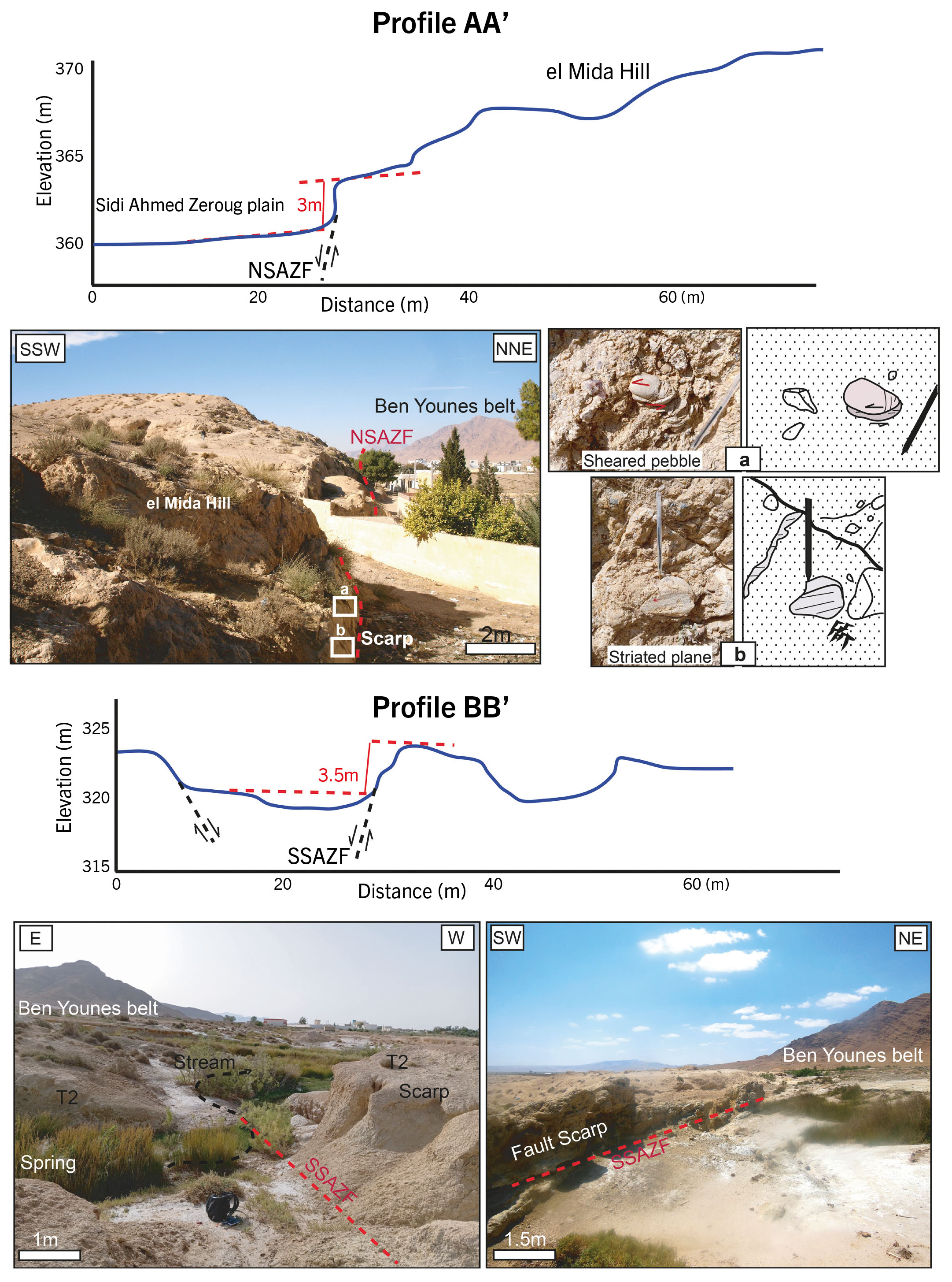
The northern strand of the Sidi Ahmed Zeroug Fault has a distinct morphological signature, marked by a well-preserved east-facing fault scarp at El Mida Hill. This scarp reaches a height of approximately 3 ± 0.5 meters and extends for about 250 meters, with a dip angle ranging between 70° and 80°. A topographic profile drawn across the fault scarp indicates that vertical offsets range from 2.5 meters to approximately 4 meters. Despite the effects of erosion and human activities, the geomorphic surface of the footwall remains intact, while the hanging wall has been slightly altered by human modifications (Fig. 7; profile AA’).
- Topographic profiles drawn along the Gafsa Fault system. Profile AA’ crosses the NSAZF that cuts the el Mida hill. Its fault scarp displays dextral movement. Profile BB’ crosses the SSAZF.
Sidi Ahmed Zeroug Site
The SSAZF separates the badland topography of its hanging wall from the low-relief footwall, where a fault scarp on the T2 terrace is clearly visible. The hanging-wall side of the studied fault segment has been incised by numerous streams, with flow directions predominantly perpendicular to the fault trace. A topographic profile across the southern fault scarp on the T2 terrace reveals that the fault has vertically displaced the T2 surface by approximately 3 ± 0.5 meters (Fig. 7; profile BB’).
DISCUSSION
Multievent cumulative slips
The assessment of offset stream channels using an effective analytical approach has been adopted to study multiple clusters along strike-slip faults, representing the cumulative slip of several recurrent earthquake events. These offset clusters help identify fault traces and provide crucial insights into the palaeoseismic behavior of the Gafsa Fault branchs. The average offset of the most recent event measured along the SSAZF is approximately 3-4 meters. Cumulative offsets of 8 meters, 11-12 meters, 16 meters, 24 meters, and 32-35 meters are roughly two, three, four, six, and seven times larger, respectively, than the coseismic offset of 3-4 meters from the most recent earthquake event that were measured along the NSAZF strand (Fig. 8). We acknowledge that the observed difference in coseismic offset values between the NSAZF (~8 m) and the SSAFZ (~3-4 m) likely reflects localised variability in surface rupture expression along different strands of the same fault system. Although both strands are part of a single, kinematically coherent fault network, their surface expressions may vary significantly due to a range of factors. First, stress distribution, or rupture propagation dynamics may influence the amount of slip preserved at the surface. The larger offset observed along the NSAZF could represent the cumulative displacement from multiple recent events, or a single high-slip event, while the smaller offset along the SSAFZ may correspond to only the most recent rupture. Second, geomorphic and structural factors can control how well surface displacements are recorded and preserved. Along the NSAZF, geomorphic markers such as channel offsets and terrace risers are more clearly preserved, facilitating the identification of larger cumulative displacements. In contrast, the SSAFZ passes through areas where erosion may obscure or reduce the visible surface expression of fault slip. Despite these local differences, we interpret the NSAZF and SSAFZ as components of a kinematically linked fault system that accommodates similar long-term deformation. The variability in surface offsets observed between the two strands emphasizes the importance of considering both structural complexity and geomorphic preservation when interpreting palaeoseismic records. Furthermore, field investigations combined with satellite imagery analysis reveal multiple stream inflections along the Jiouch, Bayaech, and Melah wadis, which correspond to dextral-lateral offsets. Notably, these channel deflections may have been produced by seismic events dating from the ate Pleistocene to the Holocene and are associated with multievent cumulative slips.
- Restoration of slip along the North Sidi Ahmed Zeroug Fault using the back-slipping method. Drainage channels labeled a-d were analyzed for cumulative displacement. A back-slip of 8 meters brings streams b/b′ into approximate alignment. Similarly, a displacement of 16 meters realigns streams c/c′ and d/d′. Stream a/a′ regains its pre-faulting morphology with a total back-slip of 32 meters.
According to the palaeoearthquake record reported by Said et al. (2011), the most recent surface-rupturing event occurred approximately 8,000 years BP, with an estimated magnitude of M ≥ 6. Based on observed fault geometries and empirical scaling relationships, such an event could have produced a coseismic lateral offset in the range of 3-4 meters. This value aligns with the smallest discrete offset observed in the geomorphic record, particularly along the SSAFZ strand, and likely represents a single-event displacement. However, the timing and recurrence of older palaeoearthquakes remain poorly constrained, as no additional palaeoseismic trenching has been conducted in the area to establish a high-resolution chronological framework. Consequently, while the cumulative lateral offsets of 8, 11-12, 16, 24, and 32- 35 meters observed across various sites suggest the occurrence of multiple surface-rupturing earthquakes, these events cannot be directly dated or individually associated with specific geomorphic features. This limitation makes it difficult to confirm whether these cumulative offsets represent a consistent sequence of six to seven well-resolved earthquake events, or whether some offsets reflect overlapping or compound displacements from closely spaced events. It also highlights the potential variability in slip per event and the need to interpret the offset record cautiously, especially in the absence of chronological control.
At the investigated sites along the NSAZF strand, where clear geomorphic offset markers are present, we estimate a Late Pleistocene slip rate of 3.53 mm/year. This is derived from the 166-meter right-lateral displacement of alluvial terraces along the Jiouch stream, dated to 47 ± 11 ka by White et al. (1996). The dating of the lowermost terrace associated with the 11.5-meter dextral offset of streams provides a maximum slip rate of 1.44 mm/year over the last approximately 7,970 years (8790 ± 50 BP and 7150 ± 70 BP; Henchiri, 2014). This indicates that during the Holocene, the slip rate of the NSAZF strand has decreased by 60%. Furthermore, no Pleistocene slip measurements are available for the SSAZF strand, as it has only displaced Holocene terraces. Our geomorphic analysis of the displaced Holocene terraces along the SSAZF segment reveals an average displacement of 2.85 meters, yielding a Holocene slip rate of 0.35 mm/year.
In addition to its dominant dextral motion, the Gafsa Fault system also exhibits a vertical component of slip. At the El Mida site, the Late Pleistocene vertical slip rate of the NSAZF segment is estimated at 0.13 mm/year, based on an average vertical offset of 3 meters and stone tools dated between 35,000 and 10,000 BP (Vaufrey, 1932; Burrolet, 1956). Notably, the increase in the Holocene vertical slip rate for the NSAZF strand, previously determined by palaeoseismic studies (0.21-0.34 mm/year; Said et al., 2011), is attributed to an intensification of the NNW-SSE principal compressive stress since the Pleistocene. As a result, neotectonic activity has become more pronounced, manifesting as right-lateral strike-slip and thrust movements along the Gafsa Fault system. Additionally, the Holocene vertical slip rate calculated for the SSAZF segment is 0.37 mm/year, which is comparable to its strike-slip rate (Tab.1).
| Gafsa Fault Strands | Age | References | Offset (m) | Slip rate (mm/year) |
|---|---|---|---|---|
| a) Lateral strike Slip | ||||
| NSAZF | 8790 ± 50 - 7150 ± 70 BP | Henchiri (2014) | 11.5 | 1.44 |
| 47000 | White et al. (1996) | 166 | 3.53 | |
| SSAZF | 8790 ± 50 - 7150 ± 70 BP | Henchiri (2014) | 2.85 | 0.35 |
| b) Vertical Slip | ||||
| NSAZF | 35000-10000 | Vaufrey (1932) Burrolet (1956) | 3 | 0.13 |
| SSAZF | 8790 ± 50 - 7150 ± 70 BP | Henchiri (2014) | 3 | 0.37 |
Earthquake hazard
Measuring the slip rate of the NSAZF and SSAZF strands is therefore crucial for assessing the long-term seismic hazard. The observed fault traces may correspond to distributed surface ruptures produced by historical earthquakes. However, these ruptures are often discontinuous and difficult to discern in the geomorphology of Gafsa due to erosion, high vegetation coverage, and the poor preservation of geomorphic offset markers from past seismic events. A more precise understanding of the temporal slip pattern of the Gafsa Fault system requires further studies aimed at determining the exact timing of past earthquakes. This can be achieved through the analysis of sedimentary deformation structures and high-resolution chronological data.
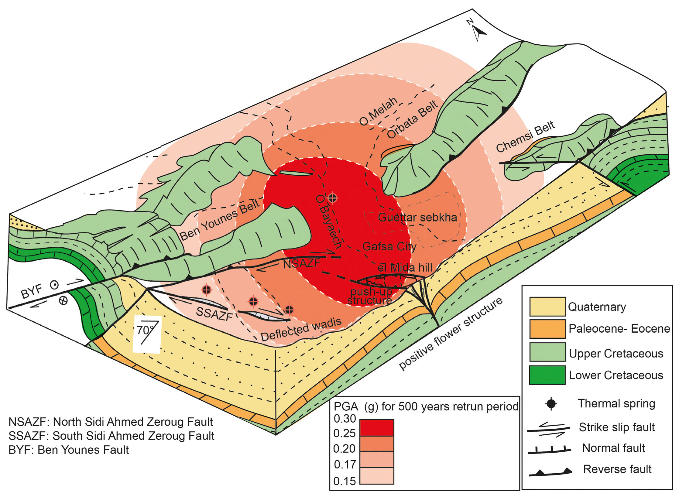
The seismic hazard map of Tunisia indicates that most of Gafsa city experiences ground acceleration between 0.25 and 0.3 g (Ksentini & Romdhane, 2014; Soumaya et al., 2016). Notably, the predicted peak ground accelerations (PGAs) for a 500-year return period align well with the region’s relatively high seismicity. These probability levels are particularly relevant for designing buildings to withstand earthquake-induced ground motion. The ground motion parameters directly correspond to the level of seismic hazard affecting different types of structures (Fig. 9).
- The three-dimensional structural deformation characteristics of the Gafsa Fault system. BYF refers to the Ben Younes Faults; NSAZF and SSAZF correspond to the North and South Sidi Ahmed Zeroug Faults, respectively. A probabilistic seismic hazard model for the Gafsa region illustrates the Peak Ground Acceleration (PGA) for a 500-year return period, expressed as a fraction of standard gravity (g), modified from Soumaya et al. (2016).
Based on the mapped fault length as the maximum surface rupture length (SRL) and following the strike-slip regression relationships (Wells & Coopersmith, 1994; Wesnousky, 2008) using the formula: log10 (SRL)=−3.55+0.74⋅M, the estimated surface rupture length of the investigated fault system, particularly the NSAZF, is approximately 25 km, based on detailed geomorphic mapping and satellite imagery. This length has the potential to generate large earthquakes with an estimated magnitude of M6.7 ± 0.2. Correlating current measurements with previous dating results and palaeo-seismological trench logs from the NSAZF and SSAZF branchs (Said et al., 2011) suggests that the well-documented seismic event of 8000 years BP could have produced a maximum magnitude of approximately 6.7. The average recurrence interval for the Gafsa Fault system is estimated to range between 300 and 5000 years, based on the ratio of coseismic offset to slip rate. Regarding the 8-meter offset, we note that this value likely represents a cumulative displacement rather than the slip from a single event. A magnitude 6.7 earthquake on a 25 km fault is expected to produce a maximum single-event displacement in the range of 3 to 4 meters, according to global empirical relations. This interpretation supports the occurrence of repeated large events along the fault and provides key constraints on its seismic potential.
Kinematic behavior of the Gafsa Fault System
We believe that the reduction in lateral slip rates of the Gafsa Fault strands may be influenced by their diverse structural styles. The development of positive flower structures and restraining bends at the fault tip area could convert horizontal displacement into vertical throw, which may be expected during a large earthquake. Our analysis of regional tectonic deformation reveals three southwest-trending smooth reliefs of distinct wavelengths within the Gafsa fault zone. The short-wavelength western ridge corresponds to Sidi Ahmed Zeroug Hill, which rises to 284 m a.s.l. The second uplifted area, El Mida-Signal Hill, reaches approximately 380 m a.s.l., while Ragoubet el Helou-Soltane stands at 370 m a.s.l. These topographic uplifts are associated with contractional stepovers, forming restraining bends. Further evidence of neotectonic activity along the Gafsa fault comes from the prominent scarp of the El Mida regional relief. Our results suggest that the spatial pattern of strike-slip movement in the Gafsa fault strands is accompanied by vertical motion observed at El Mida Hill. These findings align with gravity data analysis of Dhaoui & Gabtni (2013) and electrical surveys conducted by Mahmoudi et al. (2024), which identified several extensional graben-like structures within the Sidi Ahmed Zeroug and El Mida areas. Vertical to near-vertical resistivity gradients were associated with NW-trending normal faults.
Additionally, the intersection between the right-lateral Gafsa Fault that control the NW-trending Ben Younes-Bou Ramli belts and the eastern end of the E-trending Moulares and Metlaoui ranges likely contributes to slip heterogeneity along the Gafsa Fault plane. The decrease in the Gafsa Fault slip rate can also be attributed to strain absorption by the development of NW-oriented faults around its periphery, such as the Metlaoui, Sehib, and Tozeur-Negrine faults. These active structures have driven seismotectonic activity within the southern Tunisian Atlas, where E-W and NW-SE aligned transpressive structures and thrust faults have been identified (Boukadi, 1994; Hlaiem, 1999; Dhahri & Boukadi, 2010; Riley et al., 2011; Zouaghi et al., 2011).
CONCLUSIONS
The Gafsa Fault system consists of two roughly parallel strands: the northern and southern Sidi Ahmed Zeroug Faults (NSAZF and SSAZF). Our geomorphic analysis of well-preserved displaced stream channels indicates that the most recent earthquake event along the SSAZF produced an average offset of 3-4 m. Cumulative offsets of 8 m, 11-12 m, 16 m, 24 m, and 32-35 m correspond to approximately two, three, four, six, and seven times the coseismic offset of 3-4 m, suggesting a consistent strike-slip displacement of about 4 m per event. For the NSAZF, we calculated a Late Pleistocene slip rate of 3.53 mm/year and a reduced Holocene slip rate of 1.44 mm/year, based on right-lateral displacements of alluvial terraces and previous dating studies. The NSAZF exhibits both right-lateral strike-slip and dip-slip activity, with a Late Pleistocene vertical slip rate of 0.13 mm/year. The observed decrease in lateral slip rate is likely influenced by variations in structural styles along the fault, as well as strain absorption by nearby NW-oriented faults. Additionally, the SSAZF exhibits nearly equal lateral and vertical displacement rates, ranging from 0.35 to 0.37 mm/year.
These reconstructions of slip history along the Gafsa Fault strands provide crucial insights into seismic hazard assessment, particularly given the fault system’s proximity to the densely populated Gafsa area. Based on our analysis, we estimate a maximum expected moment magnitude of M6.7±0.2 and an average recurrence interval of 300-5000 years for major earthquakes along the Gafsa Fault system.